|
Hawaii Air-sea Logging Experiment (HALE-ALOHA)
in the School of Ocean and Earth Science and Technology at the University of Hawai'i at Manoa |
|
| » Home » HALE-ALOHA » Meterological Data | |


| |
Meterological Data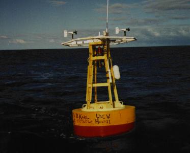
HALE ALOHA (Hawai'i Air-sea Logging Experiment, A Long-Term Oligotrophic Habitat Assessment) was initially deployed Sunday, January 12, 1997, funded primarily through the HOT Program. A key component of the physical measurments made by this mooring is the suite of meteorological instruments maintained by the Satellite Oceanography Laboratory. This system provides measurments of wind speed and direction, relative humidity, air temperature, rain accumulation, solar radiation, and air-water temperature difference. These data are transferred daily from the mooring at around 11:00 HST, and are processed two or three times a week. During periods of heavy seas or other incliment weather, the cellular link is inoperable, causing delays and some gaps in the near-real time data. As all data is recorded on-board the mooring, these gaps will appear only in the near-real time return. These near-real-time data are provided mainly to monitor the health of the mooring and assist scientists during the HOT field cruises. Instrument intercalibration and advanced processing have not been performed on these data. Please contact the Satellite Oceanography Lab prior to using these data in scientific analysis. The following data sets are available:
Text files containing the data used to make these plots are also available. These files contain variables scaled in the units used in the above plots. The wind directions have not been calibrated. A compass calibration was performed after the second deployment. This project was funded by the National Science Foundation. The meteorological system was designed and maintained by P. Flament, H. Ramm, M. Sawyer, and D. Young. | |