|
Hawaii Air-sea Logging Experiment (HALE-ALOHA)
in the School of Ocean and Earth Science and Technology at the University of Hawai'i at Manoa |
|
| » Home » HALE-ALOHA » Introduction | ||||||||||||||||||||||||||||||||||||||||||||||||||||||||||||||||||||||||||||||


| ||||||||||||||||||||||||||||||||||||||||||||||||||||||||||||||||||||||||||||||
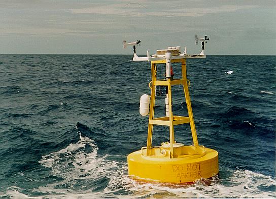
IntroductionThe inaugural deployment of the HALE ALOHA physical-biogeochemical mooring at Station ALOHA (hereafter called HALE ALOHA - I) was successfully completed on Sunday, 12 January 1997 by a team of scientists aboard the R/V Moana Wave (D. Karl, chief scientist).
I. Mooring Configuration
HALE ALOHA - I is configured as a semi-taut mooring consisting of a 3-m diameter Guardian style buoy with running lights, radar reflector, solar panel and Argos satellite position-only transmitter (and scientific instrumentation detailed below), 3/8" plastic jacketed torque balanced, wire rope and 3/4" chain (0-125 m), 5/16" plastic jacketed torque balanced wire rope (125-2000 m), 3/4" nylon line (2000-3500 m) -- short spliced to 3/4" polypropylene line (3500 - 5000 m), 36 - 17" glass floatation spheres on 34 m 3/8" chain (5000-5034 m), dual Benthos model 865A deep-sea acoustic releases on a stainless steel mount (5034-5035 m), 5 m of 1/2" chain (5035-5040 m), 10 m of 1" nylon line (5040-5050 m), 5 m of 1/2" chain (5050- 5055 m), 3600# (wet weight) anchor; total water depth (4830 m).
II. Scientific Instrumentation
III. Service Schedule
Monthly visits will be made to the HALE ALOHA mooring location during regularly scheduled HOT cruises. Each month, a Ctd cast will be taken at a safe distance from the mooring for the collection of water samples for dissolved O2, nitrate and chl a determinations. If possible, a mid-day light cast will also be taken. HALE ALOHA - I will be recovered in May 1997 and redeployed within a week of recovery. After a thorough evaluation of biofouling and other considerations, we will determine an optimal duty cycle for the mooring (4-6 months). During the May turnaround we plan to install a direct cellular phone link for the meteorological data. Additional instruments may also be added to HALE ALOHA in the future and we invite all potential users to contact Dave Karl (email: dkarl@soest.hawaii.edu; phone: (808) 956-8964; fax: (808) 956-5059) if you have any questions.
IV. Data Availability and Distribution
As with all other HOT program data sets, HALE ALOHA mooring data, including those obtained by ancillary investigators, will be available to the community as soon after processing as possible. These data will reside in a workstation at the University of Hawaii and may be accessed using anonymous ftp on Internet or the World Wide Web. More details will be posted after the mooring and its suite of scientific instruments and data are successfully recovered. Stay tuned! | ||||||||||||||||||||||||||||||||||||||||||||||||||||||||||||||||||||||||||||||