| » Home » ALOHA-CLIMAX Regional Study | ||
| ||


| ||
|
In July of 1996 a transect study was conducted to evaluate regional variability in hydrographic and biogeochemical parameters between Station ALOHA and the historical Climax study area. The cruise was made from July 8-16, 1996 on the R/V Moana Wave and covered a cruise track that overlaid the Topex-Poseidon satellite track (Figure 33). The primary purpose of the cruise was to:
Station coordinates are given in the Table below. Stations 1 to 5 were the originally planned, however, Stations 6 to 9 were added to document the development and extent of an algal bloom encountered during this cruise.
Location of stations for ALOHA-Climax 1 cruise
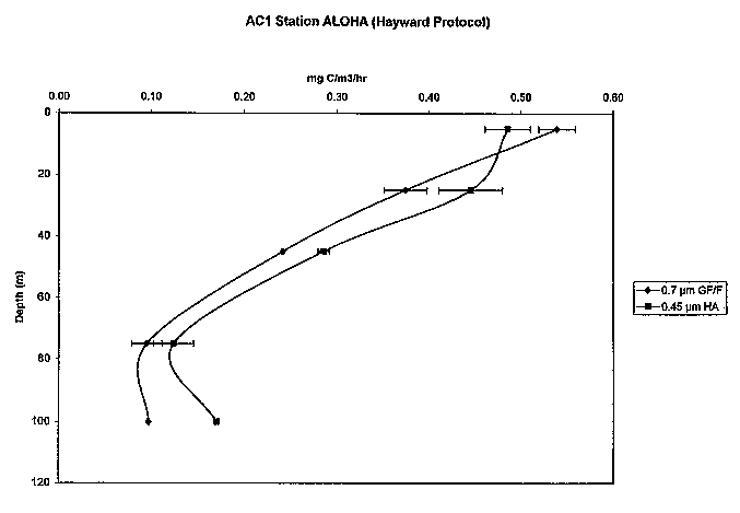
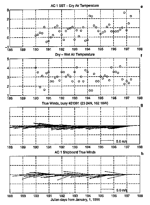
Results ( Thermosalinograph Time-series of NST and NSS measured by the thermosalinograph during AC-1 are shown in Figure 34. Large temperature and salinity gradients were encountered during this cruise which covered a long transect. Overall, temperatures range from 24.5 to 27.4 Deg C and salinities range from 34.4 to 35.3. Chlorophyll a Concentrations Profiles of chlorophyll a are shown in Figure 35. From these profiles, it appears that Station ALOHA and Climax are quite similar. The stations in between them, however, appear different, showing a subsurface maximum at Station 3 and a subsurface minimum at Station. Underway Surface Fluorescence Underway fluorescence data at 45 meters from the towed instrument is shown in figure 46. This data shows large spatial variability along the cruise track. Primary Production Depth profiles of primary production at Station ALOHA and Climax are shown in figure 47a, figure 47b, figure 47c & figure 47d. Figure 47a shows a comparison of primary production vales using the standard HOT protocol and the Climax protocol, referred to as the Hayward protocol. A significant difference is evident from water samples collected at 100 meters. Figure 47c and figure 47d show the profiles at Station Climax. Again HOT and Hayward protocols appear to produce different results with the exception of the 5 m water samples. Using various types of filters with the Hayward protocol, it appears that Millipore filters produce higher values than GF/F or than Nuclepore filters. Meteorological Observations Meteorological data collected during are presented as time series in figure 48a & figure 48b. | ||
